Cafe nearby The Neb
Isle of Man
Cafe nearby The Neb
The Neb
Poortown Road, IM4 3AD, Isle of Man, GB
contacts phone
:
+44 1624 801600
website:
www.tynwaldmills.com
Latitude:
54.208117
, Longitude:
-4.6350932
larger map & directions
read more
nearest Cafe
718 m
Tea Rooms at Tynwald Hill
Tynwald Hill, Main Road, St. John's
Cafe
Point of interest
Food
Establishment
read more
718 m
Tea Rooms at Tynwald Hill
St. John's, Tynwald Hill, Main Road
Cafe
read more
720 m
Greens Cafe
Main Road,Tynwald Hill
Cafe
read more
856 m
Wednesday Night Fish & Chips
Isle of Man
Cafe
read more
4.089 km
Shamyr Hey Tea Rooms
47 Michael Street, Peel
Cafe
read more
4.161 km
Duncans Diner
20 Michael Street, Peel
Cafe
read more
4.222 km
Tia's Teaspoon
8 Douglas Street, Peel
Cafe
read more
4.262 km
Davisons Ice Cream Parlour
1 Castle Court/Shore Rd, Isle of Man
Cafe
Store
Point of interest
Food
Establishment
read more
4.272 km
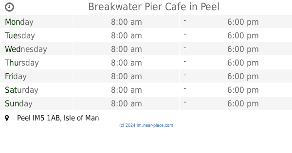
Breakwater Pier Cafe
Peel
Cafe
read more
4.293 km
Harbour Lights Café & Restaurant
The Promenade, Peel
Cafe
read more
4.325 km
Manx Ice Cream Kiosk
33 Market Street, Peel
Cafe
read more
4.329 km
Coffee Station
Peel
Cafe
read more
4.374 km
Ard jerkyll tearooms
Ard Jerkyll, Foxdale
Cafe
read more
5.603 km
The Coffee Cottage
A36
Cafe
read more
11.776 km
Cafe Villa
25 Harris Promenade, Douglas
Cafe
read more
11.829 km
Tower House Cafe
Castle Street, Douglas
Cafe
read more
11.852 km
Harbour Lights Café & Restaurant
24 Castle Street, Isle of Man
Cafe
Restaurant
Point of interest
Food
Establishment
read more
11.91 km
Coffee Republic
77 Strand Street, Douglas
Cafe
read more
12.086 km
Little Fish Cafe
30 North Quay
Cafe
read more
12.123 km
The Eatery
20a Dukes Road, Douglas
Cafe
read more
12.128 km
Cafe Delight
Duke St
Cafe
read more
12.697 km
Snaefell Mountain Summit Hotel
Isla de Man
Cafe
read more
12.697 km
Snaefell Mountain Summit Hotel
Isle of Man
Cafe
read more
15.636 km
Subway Cafe
Bridson St, Port Erin
Cafe
read more
15.809 km
Whistle Stop Coffee Shop
Railway Buildings, Station Road
Cafe
read more
📑
all categories
Accounting
Airport
Amusement park
Art gallery
Atm
Bakery
Bank
Bar
Beauty salon
Bicycle store
Book store
Bowling alley
Bus station
Cafe
Campground
Car dealer
Car rental
Car repair
Car wash
Casino
Cemetery
Church
City hall
Clothing store
Convenience store
Country
Courthouse
Dentist
Department store
Doctor
Electrician
Electronics store
Establishment
Finance
Fire station
Florist
Food
Funeral home
Furniture store
Gas station
General contractor
Grocery or supermarket
Gym
Hair care
Hardware store
Health
Home goods store
Hospital
Insurance agency
Jewelry store
Laundry
Lawyer
Library
Liquor store
Local government office
Locality
Locksmith
Lodging
Meal delivery
Meal takeaway
Mosque
Movie rental
Movie theater
Moving company
Museum
Natural feature
Neighborhood
Night club
Painter
Park
Parking
Pet store
Pharmacy
Physiotherapist
Place of worship
Plumber
Point of interest
Police
Post office
Premise
Real estate agency
Restaurant
Roofing contractor
Route
Rv park, camping
School
Shoe store
Shopping mall
Spa
Stadium
Storage
Store
Supermarket
Taxi stand
Train station
Transit station
Travel agency
University
Veterinary care
Zoo
↑